
Drainage problems often appear after grading because the ground may not hold the intended slope, and small settlement can create new low spots. Loose fill, poor compaction, and mixed soils can sink unevenly, while hardscape, downspouts, and swales may redirect water into trapped areas. In some sites, the finished grade lacks a clear outlet, so runoff collects instead of moving away, and the next details explain how those failures develop.
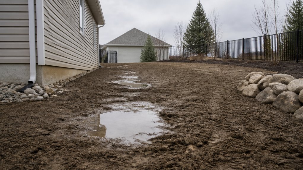
Grading can cause ponding when the finished surface is not shaped to move water away efficiently, especially if the slope is flatter than the recommended minimum or if grade changes accidentally reverse the flow.
Poor grading techniques can also ignore micro-topography, leaving broad surfaces that look level but still trap runoff. When drainage principles are not applied during design, sheet flow and concentrated flow paths may be missed, so water collects where it was not expected.
Compacted soil adds another problem, because heavy equipment can reduce infiltration and slow downward movement.
If swales, inlets, or outlets are not connected or sized correctly, water may have no escape route.
Buried hard layers or mixed soil conditions can further redirect moisture sideways, increasing surface ponding after rain.
Additionally, professional excavators factor in local Los Angeles soil variability and seismic conditions to help prevent post-grading water accumulation.
Even when a site is shaped to drain water away, new low spots can appear after grading if the soil settles unevenly or if fill was not placed with enough care.
Loose fill with poor compaction may shrink 5 to 20 percent in the first year, leaving shallow depressions that catch runoff. Thin lifts, mixed topsoil, or skipped proof-rolling also make settlement uneven, especially over soft ground.
Loose, poorly compacted fill can settle 5 to 20 percent in a year, creating shallow depressions that trap runoff.
In some yards, cut soil and fill soil compress differently, so seams and shifts sink first. Organic decay from buried roots, stump grindings, or hidden debris can create voids that slowly collapse after wetting and drying cycles.
These small dips may seem minor, yet they can hold water, signal unstable grading, and require correction before drainage problems spread.
Slope reversal often begins when the final grade is not shaped with a continuous positive pitch away from the structure. When slopes fall below the recommended 5 percent near a foundation, runoff can move back toward walls instead of away. Hardscape edges, roof discharge, and mixed surface changes can each disturb slope dynamics and create small swales that collect water. 1. Patios or walkways set too high can trap flow. 2. Short downspouts can carve channels near the footing. 3. Raised beds or berms without relief outlets can act like dams. These drainage challenges often appear subtle at first, yet they redirect sheet flow and build localized reversal. Over time, the ground surface begins to guide water toward the house, not away from it. Compacting failures during backfilling and leveling can also contribute to uneven grade that accelerates slope reversal.
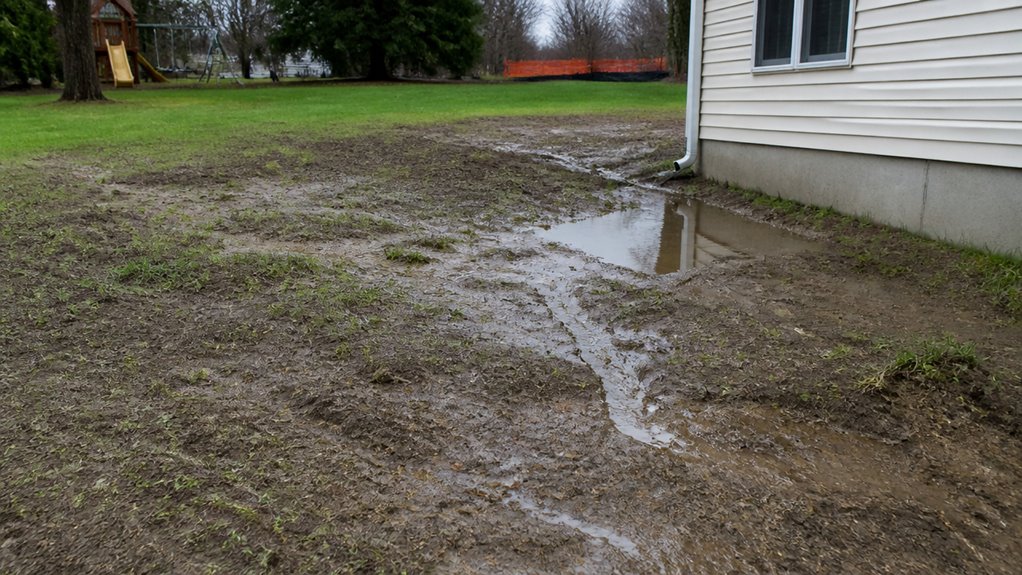
Once surface runoff has been redirected by slope issues, another common source of drainage trouble appears beneath the ground itself: settlement and compaction problems. Loose lifts, debris-filled backfill, and poor moisture control often lead to compaction failures, so the ground compresses later.
| Cause | Effect | Sign |
|---|---|---|
| Loose fill | Settlement issues | Soft spots |
| Soil variability | Uneven compression | Cracks |
| Wet or dry soil | Low density | Ponding |
When soil profiles vary, wetter pockets and dry berms move differently under load. Over time, clays may also consolidate and creep, especially where drainage paths are long. This creates differential movement near slabs, footings, and utilities, often showing up as binding doors, diagonal wall cracks, and localized depressions. Careful testing and controlled backfill placement reduce these risks.
Grading needs drainage design when slope direction, outlet location, and flow paths are not planned together, because even small mismatches can send water across finished areas or into low spots.
Careful surface flow path planning helps guide runoff to safe outlets, while drainage details at grade breaks prevent ponding, erosion, and sudden concentrated flow.
When these elements are coordinated early, the finished site performs better and avoids costly rework after construction.
Effective drainage depends on more than shaping the ground; it also requires matching finished slopes to a workable outlet system. Good slope alignment and proper outlet elevation help water leave the site by gravity, not by guesswork. When grades are too flat, paved areas can pond, unpaved areas can hold water, and subdrains may backwater against inlets.
Without this coordination, cut and fill areas can trap runoff, create depressions, or send concentrated water toward weak outlets.
Careful grading consequently becomes a drainage design task, not just an earthmoving task.
Careful surface flow path planning turns grading into a drainage strategy, because water must be guided to a reliable outlet instead of left to wander across the site.
Drainage modeling helps reveal micro low points, cut and fill reversals, and short stretches where surface runoff might stall. Designers then keep slopes positive, connect finished grades to inlets, swales, and curb openings, and align elevations so flow moves without backflow.
They also match swale inverts with downstream channels, prevent flat reaches that trap sediment, and shape transition areas between pavement and landscape so lips do not form.
After compaction, spot elevations should be checked, because settlement can shift flow paths.
Good planning keeps water moving, reduces ponding, and supports long-term site performance.
At grade breaks, drainage design shifts from simple shaping to active control, because water speeds up, slows down, or changes direction right where the slope changes. A sharp grade change can raise turbulence and shear stress, so the toe may scour, headcut, or trap sediment.
Good erosion control often depends on managing that energy before it reaches bare soil or pavement edges.
Short storms can create sudden velocity jumps, so outlets, swales, and foundations need stable conveyance and positive drainage.
Hardscape changes how water moves by turning absorbent ground into impervious surfaces, which increases runoff and raises peak flow rates.
As patios, walkways, and driveways are added, water that once spread across soil is often funneled into narrow paths, seams, and low points.
These altered flow routes can send drainage toward weak spots, where pooling, erosion, or further damage may begin.
When grading replaces soil and vegetation with pavement, roofs, curbs, and gutters, rainwater can no longer soak into the ground as it once did. This shift changes flow dynamics and complicates runoff management because more water moves across the surface, faster and in greater volume.
As flow becomes focused, storm sewers and paved channels deliver water quickly to streams, leaving little time for settling or detention. The result is a flashier response, higher peak flow, and added stress on downstream drainage infrastructure.
As runoff increases across pavements, roofs, and gutters, the shape of the site begins to control where water can travel, and hardscape often redirects flow in ways that natural ground once did.
Walkways and driveways can turn sheet flow into narrow channels, changing drainage patterns and pushing water toward foundations or low spots. Even small slope differences can shift runoff paths, while long straight runs increase speed and erosion.
At edges, poor alignment between hardscape and soil creates saturated borders, joint washout, and algae growth. Settled slabs or pavers form low spots that collect water.
Construction compaction also lowers infiltration beside hardscape, so more water becomes runoff. This hardscape impact often reveals itself through repeated ponding, scour, and concentrated discharge.
After grading appears complete, the site can still change in ways that trap water. Settlement, vegetation growth, and utility influences often reshape slopes after construction, so runoff follows a different path than the original plan.
Freeze-thaw cycles, equipment traffic, and added hardscape can deepen these problems over time.
Because these changes happen gradually, a yard may look finished while water quietly pools where drainage once worked.
Drainage issues usually appear within the first storm to six months after grading, when grading effects are first tested by rainfall. Some problems show up right away as pooling or runoff toward structures, while others develop over weeks or months as soil settles.
In longer drainage timeframes, especially six months to three years, subtle low spots and chronic wet areas often reveal deeper drainage flaws and poor subsurface flow.
Yes—tiny grade errors can release a pond the size of a lake in a backyard.
When grade accuracy is off by even 1 to 2 percent, water flow can shift into low spots, ruts, or closed basins. That small change may stop runoff from leaving the area, so water collects instead of draining.
Clay soils and compacted ground make the problem worse, because infiltration stays slow and ponding lasts longer.
Clay soils and soil compaction usually make drainage problems worse, because they hold water, limit soil permeability, and distort drainage patterns after grading.
Sandy soils drain quickly, but loose layers can shift and create uneven flow.
Loamy soils are often more balanced, yet they still fail when disturbed by poor grading techniques.
Together, these soils influence water retention, runoff, and ponding, so site conditions must be matched carefully to the soil type.
Yes, landscaping changes can reshape finished grading like wind reshaping sand.
New plantings, roots, mulch, patios, and irrigation all create landscaping impact that alters slope, runoff, and soil moisture. Good grading techniques must account for these additions, because even small changes can form low spots or direct water toward buildings.
When design and maintenance are coordinated, the final grade stays functional, stable, and far less likely to drain poorly.
Finished grades should be inspected at 1, 3, 6, 9, and 12 months after construction, then annually for the first 3 to 5 years.
Additional checks are wise after major storms, spring thaw, dry spells, or landscaping changes.
This inspection frequency helps confirm that grading standards are still being met, while also revealing settlement, erosion, or ponding before they become serious drainage problems.
To summarize, drainage problems after grading usually appear when the finished surface does not guide water as planned. Small low spots, slope changes, settling, and hardscape features can quietly upset runoff patterns. When the whole picture is considered, proper drainage design can prevent water from becoming a headache later. Careful grading, paired with smart planning, helps keep landscapes stable, dry, and functional, proving that an ounce of prevention is worth a pound of cure.
A Los Angeles project needs engineered grading when cut and fill exceed 5,000 cubic yards, when excavation is large, or when site hazards raise stability concerns. Hillside properties, Chapter 70 areas, and lots in mapped hillside zones often require it too. A licensed civil engineer must prepare approved plans, along with geotechnical and geology reports, before permits are issued. Inspections, contractor licensing, and haul route review may also apply, and more details help explain why.
Engineered grading in Los Angeles is required whenever a project crosses certain volume, safety, or site-condition thresholds. Under local grading definitions, any cut and fill combined reaching 5,000 cubic yards, or any excavation exceeding that amount, meets the engineered requirements.
Even smaller projects may be classified this way if the permittee chooses, or if a building official identifies special hazards, structural support needs, geologic concerns, or erosion issues. In these cases, a licensed civil engineer must prepare approved plans, supported by geotechnical and geology reports.
The work also needs separate permits, licensed contractors, and department inspection. This framework helps guarantee that grading is reviewed carefully, documented fully, and carried out safely before construction moves forward.
When compliance with local construction codes is required, having an engineer-driven grading plan helps ensure the work matches Los Angeles standards from the start.
Hillside areas in Los Angeles change the grading rules by activating Chapter 70 compliance and other hillside ordinance requirements, which apply beyond standard grading regulations.
Once a property is mapped as hillside, engineered grading becomes mandatory, and permit approval must follow the required review sequence before work can begin.
These rules also limit grading quantities and can affect whether a permit is issued at all.
When a project site falls within a mapped hillside area, the grading rules change in important ways, because building permit approval under the Baseline Hillside Ordinance must come first and can control whether grading permits are issued at all. Under hillside regulations, import or export of earth may be limited, and Maximum Grading Quantities set the ceiling for a property.
| Trigger | Effect | Note |
|---|---|---|
| Mapped hillside area | Ordinance applies | Verify official maps |
| Building approval | Required first | Controls grading permits |
| MGQ exceeded | Extra review | Quantities are capped |
| Remedial grading | May be exempt | Does not count toward MGQ |
Single-family residential lots in R1, RS, RE, and RA zones often face stricter review. Accurate site location, plus clear grading descriptions, helps keep the permit process orderly and predictable.
In Chapter 70, hillside areas change the grading process in a significant way because projects in these locations are treated as engineered grading regardless of how much earth is moved. This rule means a civil engineer must prepare and approve the plans, and the permittee cannot choose a simpler path.
The Department of Building may also require engineered grading when special conditions or unusual hazards appear. Under hillside regulations, professional inspection is required from a civil engineer, soils engineer, and engineering geologist. They observe compaction, perform exploratory work, and submit reports during active grading.
These reports address soil strength, geology, slope stability, and site safety. In practice, the chapter adds careful oversight, which helps protect hillside projects and supports safer construction decisions.
What, then, triggers the 5,000-cubic-yard threshold in Los Angeles grading projects? Any cut or fill operation that reaches 5,000 cubic yards, or a combined total that hits that amount, activates engineered grading. The rule applies in both hillside and non-hillside areas, so the volume itself is the key factor. These threshold implications matter because projects near the limit need civil engineer-prepared grading plans before work proceeds. Even smaller projects may shift into engineered status when special site conditions, unusual hazards, or adverse geology are present. In hillside designations, the exemption disappears entirely. That means grading strategies must account for both quantity and site risk, since support for structures also triggers engineered requirements. Excavation contractors must coordinate closely with engineers and site managers to ensure the engineered grading plan matches real-world earthmoving conditions.
Engineered grading in Los Angeles must first be approved through a civil engineer’s signed and stamped grading plan, which establishes the technical basis for the work.
That approval then moves through agency review, where the Department of Building and Safety, and other required city officials, verify compliance before a permit is issued.
Together, these approvals guarantee the plan meets engineering standards, planning conditions, and site safety requirements.
Civil engineer approval is a central requirement for engineered grading in Los Angeles because the engineer is responsible for the design, technical review, and professional oversight of the work.
These civil engineer roles support grading compliance from the first plan submission through completion, especially when cuts or fills exceed 5,000 cubic yards. The engineer prepares the grading plans, reviews revisions when field conditions change, and coordinates with soils engineers and engineering geologists.
Professional inspection includes observing line, grade, and surface drainage, which fits the engineer’s technical specialty. For hillside tract grading, the civil engineer or responsible land surveyor also submits as-graded plans at the end.
This approval process helps confirm that the work matches the permit, code requirements, and approved design.
Before grading can move forward in Los Angeles, several agencies may need to review and approve the project, because engineered grading affects zoning, drainage, geologic safety, and site-specific development conditions.
The Department of Regional Planning verifies that land use, plots, and permits match Title 21 and Title 22 before grading plans are issued.
The Geology and Soils Section reviews current soils and geologic reports, while the Land Development Division checks hydrology and Low Impact Development requirements.
In hazard areas, geotechnical review may also address faults, liquefaction, and slope instability.
Fire, coastal, or regional agencies can be added through referral sheets.
This agency coordination shapes approval timelines, since revised plans, stamped sheets, and jurisdictional letters may all be required before final clearance.
Haul route approval is required in Los Angeles when a project imports or exports 1,000 cubic yards or more of earth material, and that total is measured across the full duration of the job.
At this point, the haul route and approval process move from a minor review to a formal routing requirement. The same threshold applies to both import and export operations, so either direction can trigger review.
In Hillside Construction Regulation districts, this level also requires Board of Building and Safety Commissioners approval.
The rule separates small grading work from larger projects that need coordinated truck routes, posted conditions, and official oversight.
When volumes rise further, especially in engineered grading projects, additional scrutiny may follow under city grading rules.
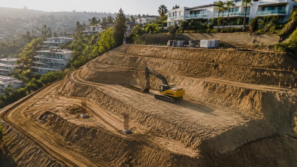
Grading inspections bring several specialists together to verify that earthwork is being completed exactly as approved. Civil engineers coordinate field checks, survey stakes, and plan review, while soils engineers watch ground preparation and fill placement.
Their Inspection Procedures include Compaction Testing, density readings, and notes on equipment, soil sources, and inspection intervals.
Engineering geologists examine bedrock excavation to confirm conditions match approved reports and that adverse geologic issues have been addressed.
Department inspectors compare the permit set with actual site conditions, including legal descriptions and hillside requirements.
Written reports document each visit, and revised recommendations are issued if conditions differ from earlier studies.
Together, these reviews confirm that grading work follows approved plans, supports site safety, and produces a record for final certification.
On hillside projects in Los Angeles, earthwork is not just a construction task; it is one of the earliest forces shaping the entire design. The city’s grading limits often control building size before plans are finished, because grading impacts foundation choices, retaining walls, and site layout.
Spread footings may use more cut and fill than caissons, so a different foundation can keep a project within the Baseline Hillside Ordinance. If the limit is exceeded, review becomes slower and more expensive, with haul routes, export, and bonding adding cost implications.
Early grading decisions also affect geology, shoring, and slope stability work. For this reason, architects and engineers must coordinate from the start, since later changes are usually difficult and costly to recover.
Yes. A project may choose engineered grading before reaching the threshold, and the choice often starts with project specifications and grading regulations.
For example, 1 in 10 smaller sites can adopt this route to gain stronger oversight. By electing it early, the permittee accepts the full engineered grading requirements, including professional plans, inspections, and certifications.
This voluntary option can improve safety, document site conditions, and help prevent surprises during construction.
The Building Official determines whether unusual hazards require engineered grading, and the Superintendent of Building may also make that decision when hazardous conditions are involved.
Their hazard assessment can rely on inspections, geologic reviews, and soils reports. If the site shows instability, seismic risk, or threats to property, the project must follow engineering standards.
This authority helps guarantee unsafe grading is identified early and corrected with careful oversight.
Yes. In hillside areas, even a small excavation can trigger engineered grading, because the rules act like a locked gate, not a sliding scale.
Hillside stability becomes the priority, and excavation regulations require professional review regardless of volume. A project on a designated hillside lot must follow engineered grading standards, while non-hillside sites usually use the 5,000 cubic yard threshold.
This keeps steep-slope work safe, controlled, and properly documented.
Final grading certification usually needs an engineer-of-work statement of compliance, signed and stamped by a California civil engineer, plus accepted compaction reports from the soils engineer.
As-built grading plans approved by city staff, and a landscaping or erosion-control certification letter are also required.
These documents complete the grading certification process and serve as required documentation showing the work matches approved plans, meets density standards, and supports final site stability with confidence.
Yes—foundation choices can reduce grading quantity and, in some cases, lower permit requirements.
Like a lever on a machine, the right foundation types can improve grading efficiency by limiting excavation, retaining more soil on-site, and reducing haul-off needs.
Caisson foundations, for example, may count differently in grading totals than conventional footings.
This can help a project stay within local limits, avoid extra reviews, and simplify approval while still meeting structural and geotechnical needs.
Engineered grading becomes necessary in Los Angeles when site conditions, project size, or hillside terrain create added risk. A notable statistic is that many grading permits require special review once cuts or fills exceed 5,000 cubic yards, showing how quickly a project can move into a more complex process. Careful planning, approved haul routes, and regular inspections help protect safety, reduce delays, and keep designs aligned with city requirements.
Los Angeles expansive soils form when smectite clays, such as montmorillonite, take in water and swell, then shrink during dry periods. Local basin-fill clays and moisture shifts from grading, leaks, and stormwater increase movement risk. A geotechnical report should include Atterberg limits, percent passing No. 200, swell index, and swell-pressure or related tests. Codes often require special foundation prep when PI and expansion criteria are met. Moisture control, drainage, and appropriate shallow or deep foundations reduce cracking, and the next details explain how.

Los Angeles soils can become expansive when certain clay minerals, especially smectite-group clays like montmorillonite, are present in local deposits and can absorb water between their layers. This process creates high swell potential as interlayer water increases volume.
Fine-grained basin-fill clays and clayey silts, often derived from weathered sedimentary and alluvial sources, dominate many areas and heighten expansion risk. Upland hillsides can also contain residual clays in saprolite and weathered bedrock pockets, where moisture fluctuation triggers repeated shrink–swell cycles.
A Mediterranean climate adds strong seasonal wet–dry cycles, while drought, then heavy rain, can rapidly rewet dry clays. Urban fill, grading, irrigation, leaks, and stormwater shifts further concentrate or remove moisture, creating uneven swelling. Evidence can appear as cracked pavements. For this reason, professional site preparation and drainage-focused excavation are key to managing moisture around foundations in Los Angeles.
After identifying that Los Angeles soils can become expansive through cycles of drying and rewetting, a geotechnical investigation needs test results that can quantify shrink–swell behavior rather than just describe it. A proper lab package should include Atterberg limits (PI via ASTM D4318), percent passing No. 200 (ASTM D422), and an expansion assessment using swell index from ASTM D4829, since PI ≥ 15 and expansion index >20 often signal expansiveness. undisturbed sampling supports free-swell or oedometer measurements, while swell-pressure tests help estimate uplift forces. Field data should be logged with moisture correlation using in-situ moisture and density.
| Test | Standard | Purpose |
|---|---|---|
| PI | ASTM D4318 | Plasticity classification |
| Percent fines | ASTM D422 | Expansive criteria support |
| Swell index | ASTM D4829 | Quantify expansion |
| Swell pressure | Oedometer | Uplift-force estimate |
In Los Angeles, the “active zone” where soil moisture changes most is often cited as roughly 3 to 5 feet for many residential sites, though some deeper cases average around 18 feet.
Its thickness is shaped by soil type, especially expansive clays, plus vegetation, irrigation practices, grading and imported fill, and even leaking utilities that shift moisture patterns over time.
Because these conditions vary widely from lot to lot, local design teams typically rely on site-specific geotechnical borings and lab testing rather than using one generic depth.
For foundation excavation planning, excavating crews typically coordinate closely with the geotechnical findings to manage depth and stabilize grades before construction begins.
A practical way to understand foundation performance in Los Angeles is by tracking the active zone, the soil layer that repeatedly expands and contracts with moisture changes.
Typical local guidance places the active zone depth, often tied to foundation depth planning for expansive clays, in a common 3 to 5 foot range. Many contractors and prescriptive manuals reference 3–5 feet when choosing designs such as deepened footings or void forms.
County requirements also set minimum embedment controls, including exterior foundations extending about 24 inches below undisturbed ground, and interior slab treatments linked to roughly 18 inches.
Still, engineering estimates for some sites broaden to 3–8 feet, and unusual moisture conditions can push values higher.
Active zone thickness in Los Angeles is shaped by several interacting site conditions, which together determine how far moisture changes travel into the soil profile and how strongly expansive clays respond.
In Los Angeles, active zone dynamics depend first on soil type and mineralogy: high-smectite, greater clay content, and plasticity usually increase shrink–swell and help moisture fluctuation effects reach deeper.
Natural layering can also concentrate activity where expansive layers connect. Collapse potential, cementation, and stratigraphy influence whether wetting creates large heave or smaller settlement.
Near-surface moisture drivers matter too. Trees, irrigation, grading, storm patterns, and leaks can push wetting fronts downward over time, not just during dry seasons.
Finally, shallow or perched groundwater, permeability, and regional recharge shift where moisture remains seasonally active.
How do Los Angeles building codes decide when expansive-soil foundation preparation is needed?
Building officials may require soil testing when expansive soils are likely to exist, especially if local maps or quantifiable data show potential for expansive, compressible, or questionable ground.
Subdivisions often trigger geotechnical reports when preliminary studies flag critically expansive lots.
A seismic design category C or greater commonly requires soil classification, and city or county amendments can expand testing triggers beyond model codes.
Expansive soil criteria include PI ≥ 15, enough fine-grained material passing the No. 200 sieve, and sometimes an expansion index over 20.
Once identified, foundation design must manage differential volume change, using engineered systems, prescriptive detailing, or removal, stabilization, and tied reinforcement.

Choosing a moisture plan is one of the most effective ways to protect expansive-soil subgrade performance in Los Angeles, because even small swings in water content can trigger swelling and shrinkage.
Choosing a moisture plan in Los Angeles helps protect expansive-soil subgrades, since even minor water-content swings can cause swelling and shrinkage.
The plan begins with moisture management through positive grading, a 3–5 ft perimeter apron, and rainwater control using gutters that discharge 5–10 ft from the foundation.
Surface moisture barriers, such as geotextile or 6–10 mil polyethylene, reduce vertical water movement into the active zone.
For active moisture control, irrigation strategies should use drip lines placed 3–5 ft out from the foundation, not near footings, and automated scheduling with soil-moisture sensors.
Slow, frequent applications help maintain a uniform setpoint and reduce cyclic movement.
In Los Angeles, the best foundation type for expansive soils depends on how far the structure is expected to move when the soil swells and shrinks with moisture changes.
Expansive clays, including montmorillonite-rich layers, raise vertical heave risk, so engineers evaluate swell potential through lab testing and define the 3–10 ft moisture-active zone.
Shallow foundations can work when the design counters moderate movement, using correct embedment, reinforced slabs or mats, and moisture barriers, plus site-specific controls.
Deep foundations become more attractive when borings show low near-surface bearing, layered heterogeneity, or perched water that reduces capacity.
Piers, piles, and caissons transfer loads to non-expansive strata, and their embedment depth can be adjusted.
Expansive-soil cracks typically develop when moisture changes cause the clay beneath or near a foundation to swell upward and later shrink, creating repeat cycles of movement. Crack identification starts with visible patterns and locations: stair-step cracking in masonry or CMU, diagonal cracks from corners, and horizontal cracks near retaining or stem walls. Vertical slab cracking often pairs with localized heave, such as uplifted corners and uneven floors. Gaps at door or window frames, sticking doors, or misaligned sashes also signal differential settlement.
| Check | What to note |
|---|---|
| Timing | Worse after winter wetting |
| Triggers | Irrigation, leaks, landscaping changes |
| Monitoring | Measure widths, use level surveys |
| Prevention | Moisture management steps |
For a practical checklist, control drainage, extend downspouts, fix plumbing fast, and maintain irrigation distances. Install capillary breaks and crack monitors when needed.
Yes. In many Los Angeles neighborhoods, tree roots can increase expansive soil risk near foundations by lowering soil moisture during dry periods.
Species with high transpiration and deep or wide rooting, such as eucalyptus, ficus, and large oaks, can pull water from clays, raising matric suction and promoting shrinkage.
That shrinkage can reduce foundation stability, contributing to cracks, settlement, or edge heave, especially for shallow slabs and footings.
For a typical single-family lot, geotechnical soil testing usually uses one to two borings for simple, flat sites, enough for basic foundation design.
Many projects require a minimum of two borings to capture local variability, especially in infill settings.
Borings are often drilled to about 15 to 20 ft, and deeper boring depths may be needed if the plan uses drilled footings or slab conditions suggest variability.
Expansive soils compacted at the wrong moisture content can cause major problems, since swell is driven by how water changes the soil’s structure.
If compacted too dry of optimum, moisture balance during wetting can trigger large heave, because suction loss lets the clay rapidly expand.
If compacted too wet, swelling may be smaller initially, but strength can drop, and pore pressures can linger.
Proper compaction techniques and moisture checks reduce both risks.
Yes, a project can often build on expansive soil without piers using engineered solutions. A geotechnical engineer must confirm soil properties with ASTM testing, then design a stiffened or post-tensioned slab, proper dowels, and reinforcement to resist heave and differential movement.
The build also relies on moisture control via vapor barriers and drainage. In some cases, soil stabilization through lime/cement or soil mixing can reduce swelling enough for a shallow slab.
Moisture conditioning and compaction for expansive soils get checked with inspections that sound simple, yet are not. Inspectors confirm moisture testing at each compaction lift, using oven-dry or calibrated meters, and verify results hit the target range, typically a few percent above OMC.
They also perform compaction verification with nuclear density gauge or sand cone, computing percent relative compaction against ASTM Proctor values. Records, retesting after failures, and proof-rolling documentation usually complete the process.
In Los Angeles, expansive soil is like a cautious traveler, changing mood with moisture and then moving the ground beneath homes. With proper expansive-soil tests, engineers can map the active zone, then decide whether the code demands foundation prep. A smart moisture plan steadies the subgrade, while choosing shallow or deep foundations fits the soil’s behavior. By watching for early crack signs, homeowners and builders can prevent small warnings from becoming costly lessons.
Skip to content